Hermit's Cave
Dive into Legend at Hermit’s Cave: A Site Steeped in Mystery and Marine Life
Hermit’s Cave is a unique and evocative dive site located beneath the rocky promontory near Punta Chiappa, where legend and underwater beauty come together. The site takes its name from a natural cave perched above the waterline—said to have been the solitary refuge of a hermit named Giovanni in the 4th century AD. Stories tell of ghostly lights seen at the cave’s entrance after his death, and his remains are said to rest in the ancient church of Ruta, remembered for their sweet scent.
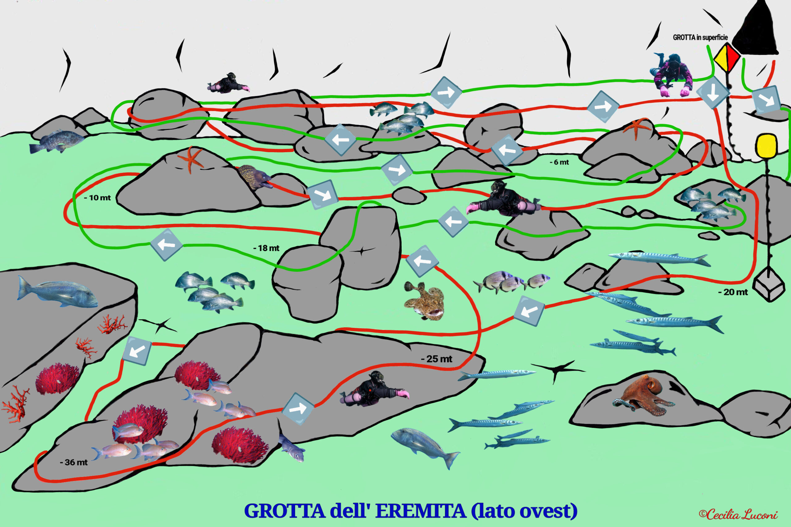
Underwater, the site offers a fascinating mix of rockfalls, canyons, and overhangs teeming with life. From large brown groupers and moray eels to octopuses, conger eels, and even small-spotted catsharks, Hermit’s Cave never fails to surprise. The area is best explored in clear conditions and is suitable for both beginner and advanced divers, with red and green routes offering depth options down to 40 metres.
🔴 RED ROUTE (down to -40 m)
-
After the pre-dive check, we’ll descend to the mooring block at around -20 m.
-
In this bay, large brown groupers can often be seen entering and exiting their dens beneath the rocks.
-
With the wall on our right, we’ll head south-west until we reach the mouth of a canyon formed by massive rock structures extending down to -36 m.
-
From here, we’ll reverse direction and begin ascending, gliding over the large boulder that had been on our left during the canyon descent.
-
At -18 m we’ll swim among the rockfall boulders, continuing to ascend until we reach the main wall of the promontory or the chain connected to the mooring buoy.
🟢 GREEN ROUTE (down to -18 m)
-
After the pre-dive check, we’ll descend along the wall and find a reference point at -6 m to help us relocate the boat at the end of the dive.
-
We’ll reach a maximum depth of -18 m, swimming south-west with the wall on our right, near large boulders that we’ll scan with torches in search of conger eels, octopuses, moray eels, and small-spotted catsharks tucked into the rocks.
-
After about 15 minutes, with the promontory now on our left, we’ll ascend to around -10 m, zigzagging through the boulders that make up the rockfall. A hunting school of dentex chasing damselfish will likely grab our attention!
-
At -6 m, we’ll continue swimming through the rocks, first with the wall on our right, then switching to keep it on our left as we return to our earlier reference point. Once there, we’ll perform our 3-minute safety stop at -5 m.
-
Depending on visibility, we’ll decide whether to exit there or head to the mooring chain.
Dive Hermit’s Cave with Diving Group Portofino
- Location: Near Punta Chiappa, under the promontory
- Access: Boat dive
- Best conditions: Calm sea, good visibility
- Depth: 18 m (Green Route) | 40 m (Red Route)
- Difficulty: From beginner to advanced
Want to explore a dive site steeped in legend, with canyons, rockfalls, and encounters with groupers, moray eels, and catsharks? Book your dive at Ermit’s Cave with Diving Group Portofino today!


